Do’s and Don’ts pertaining to Earthquake Hazard  |
| |
- Gujarat is located in the “Himalayan Collision Zone”-where Indo-Australian tectonic plate slides under Eurasian plate-causing active fault lines beneath.
- The Vulnerability Atlas of India (BMTPC, 1997) classifies Gujarat into four classes based on a base of 10.3 million buildings recorded in the 1991 Census and BIS standard (IS: 1893 1984).
- The proportion of area in Gujarat that falls into these (MSK Intensity Scale) zones is as follows:
- Very High Risk: >MSK IX (19 percent)
- High: MSK VIII (13 percent)
- Moderate: MSK VII (66 percent)
- Low Damage: <= MSK VI (1 percent)
- Kutch District located in Very High Risk Seismic Zone – V.
- Parts of Jamnagar, Rajkot, Patan and Banaskantha in High Risk Zone – IV.
- Most other parts of the State lie in Moderate Zone - III and a very small part in Low Damage Zone – II.
- Earthquake risk is very high in Gujarat and the State has suffered major earthquakes in - 1819, 1845, 1847, 1848, 1864, 1903, 1938, 1956 & 2001 (9 times in past 200 years). The 2001 Kachchh earthquake was the third largest and second most destructive earthquake in India over the last two centuries.
|
| Earthquake Hazard Maps : |
- In order to provide a guiding framework to undertake mitigation investments and activities, GSDMA initiated a study for preparation of a Composite Hazard Risk & Vulnerability Atlas for the State covering six natural and man-made hazards and the physical, social and economic vulnerability of its people, assets and economy at Taluka-level. The hazards that have been examined in detail using advanced computer assisted GIS models, probabilistic analysis and detailed field studies include: earthquake, cyclone, storm surge, flood, chemical accident exposure (between 25 and 200 year return period), and importantly for Gujarat – drought, over a period of a century.
- Based on the seismic risk exceedence probability database - four Earthquake Hazard Risk Maps (for 25, 50, 100 and 200-year return periods) were created at PGA values defined based on IS: 1893 (Part1) 2002 classes.
- Earthquake Hazard Risk Zonation Maps for a return period of 25 years, 50 years, 100 years and 200 years already available in the old website could be uploaded on this page with a brief description of each Map as shown below
GUJARAT HAZARD RISK ZONATION: 25-YEAR RETURN PERIOD ESTIMATED MEAN TALUKA PGA (IN G)
|
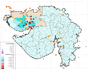 The estimated mean Taluka PGA (in g) zonation for a 25-year return period is presented in the adjacent figure. The location and magnitude of major events is also located on the map to assist in identifying key driving factors for the zonation. Kachchh district has two pockets of low to moderate intensity with the maximum estimated PGA values between 0.05 to 0.10 g. This is primarily because of the large number of relatively frequent low magnitude events in this region. The estimated mean Taluka PGA (in g) zonation for a 25-year return period is presented in the adjacent figure. The location and magnitude of major events is also located on the map to assist in identifying key driving factors for the zonation. Kachchh district has two pockets of low to moderate intensity with the maximum estimated PGA values between 0.05 to 0.10 g. This is primarily because of the large number of relatively frequent low magnitude events in this region. |
GUJARAT HAZARD RISK ZONATION: 50-YEAR RETURN PERIOD ESTIMATED MEAN TALUKA PGA (IN G)
|
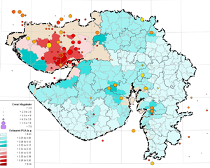 The estimated mean Taluka PGA (in g) zonation for a 50-year return period is presented in the adjacent figure. This zonation would typically be used for the design of houses and much of the non-engineered building stock that would need to have a mean design service life of 50 years. Four moderate to very high intensity pockets are located in Kachchh and north coastal Rajkot and Jamnagar districts clustered around the major events in this region – the 1956 Anjar earthquake and the 2001 Kachchh earthquake with a peak PGA value in excess of 0.36 g. Five moderate intensity pockets emerge in Baruch, Bhavnagar, Sabarkantha districts and north coastal Saurashtra with mean PGA values that reaching up to 0.16 g. The estimated mean Taluka PGA (in g) zonation for a 50-year return period is presented in the adjacent figure. This zonation would typically be used for the design of houses and much of the non-engineered building stock that would need to have a mean design service life of 50 years. Four moderate to very high intensity pockets are located in Kachchh and north coastal Rajkot and Jamnagar districts clustered around the major events in this region – the 1956 Anjar earthquake and the 2001 Kachchh earthquake with a peak PGA value in excess of 0.36 g. Five moderate intensity pockets emerge in Baruch, Bhavnagar, Sabarkantha districts and north coastal Saurashtra with mean PGA values that reaching up to 0.16 g. |
GUJARAT HAZARD RISK ZONATION: 100-YEAR RETURN PERIOD ESTIMATED MEAN TALUKA PGA (IN G)
|
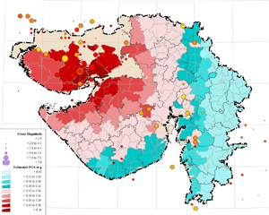 The estimated mean Taluka PGA (in g) zonation for a 100-year return period is presented in the adjacent figure. This zonation would typically be used for the design of critical buildings that need to have a mean design service life of 100 years. All of Kachchh, almost the entire coastline of northern Saurashtra that adjoins Kachchh and a small area in Patan district fall into the very severe intensity zone over a 100-year return period. This closely follows the pattern of damage that was observed in the 2001 Kachchh earthquake. The severe intensity zone extends in a broad sweep from north Gujarat, through central Gujarat and much of central Saurashtra. The cities of Ahmedabad, Baruch, Rajkot, and Bhavnagar fall into the severe intensity zone, while Bhuj and Jamnagar fall in the very severe intensity zone over this time frame. The boundaries of key structural features emerge in this zonation map with the broad boundaries of the Cambay Graben and the eastern hilly region emerging due a mix of the influence of active faults, distance from historical events and ground amplification due to the deep alluvium within the basins. The eastern hilly region of Gujarat consists of stable Granatoids and Basalt has relatively low estimated intensities – a departure from seismic zonation under the current revision of IS:1893. The estimated mean Taluka PGA (in g) zonation for a 100-year return period is presented in the adjacent figure. This zonation would typically be used for the design of critical buildings that need to have a mean design service life of 100 years. All of Kachchh, almost the entire coastline of northern Saurashtra that adjoins Kachchh and a small area in Patan district fall into the very severe intensity zone over a 100-year return period. This closely follows the pattern of damage that was observed in the 2001 Kachchh earthquake. The severe intensity zone extends in a broad sweep from north Gujarat, through central Gujarat and much of central Saurashtra. The cities of Ahmedabad, Baruch, Rajkot, and Bhavnagar fall into the severe intensity zone, while Bhuj and Jamnagar fall in the very severe intensity zone over this time frame. The boundaries of key structural features emerge in this zonation map with the broad boundaries of the Cambay Graben and the eastern hilly region emerging due a mix of the influence of active faults, distance from historical events and ground amplification due to the deep alluvium within the basins. The eastern hilly region of Gujarat consists of stable Granatoids and Basalt has relatively low estimated intensities – a departure from seismic zonation under the current revision of IS:1893. |
GUJARAT HAZARD RISK ZONATION: 200-YEAR RETURN PERIOD ESTIMATED MEAN TALUKA PGA (IN G)
|
| The estimated mean Taluka PGA (in g) zonation for a 200-year return period is presented in the adjacent figure. This zonation would typically be used for the design of critical infrastructure and buildings that need to have a mean design service life of 200 years. All of Kachchh, much of Northern, part of Central and all of North coastal Saurashtra falls into the very severe intensity zone. Eastern Gujarat (except for small pockets in Dahod and Dangs districts) rises to moderate intensity, while the rest of north, central Gujarat and south coastal Saurashtra falls into the severe intensity zone. All the major cities of Gujarat fall either into the very severe or severe intensity zone, except for Valsad, Vapi and Navsari in south Gujarat. |
| |
| Important links for further information |
| Institute of Seismological Research (ISR) |
| Indian Meteorological Department (IMD) |
| GSDMA Leaflets In Gujarati |
|